

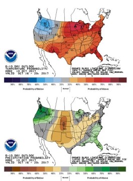
 US Forecast Drier Next Week; Soaking Rain Retuns Oct 21-25?: The GFS model maintains another round of widespread and potentially heavy rainfall in the last week of October, but so far neither the EU nor Canadian models back this up. NOAA’s 6-10 day outlook is at left, and next week looks to be rather favorable for harvesting.
In the near term, moderate showers will work across the Central & Eastern Midwest into Thursday. Follow up rainfall is indicated on the weekend, and heavy totals (2-3”) are offered to MO, IA, IL and WI. Dry weather prevails elsewhere.
A more zonally flowing jet stream in the 6-10 day period, will keep precip isolated to pockets of Central Canada. Complete dryness and normal/above normal temps are projected across the whole of the Central through the duration of next week. Freezing overnight lows will be more common across the N Plains and Upper Midwest thereafter, but crops in the Dakotas should be fully mature in the next 10-12 days.
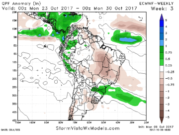 Brazilian Dryness Likely Sustained Through End of October: The forecasting models still lack a meaningful pattern shift to wetter weather in Central & Northern Brazil, and there’s evidence that dryness may continue for another 2-3 weeks. The EU model’s 15-21 day forecast is below, which will drag abnormally dry conditions into the end of the month. Heavy rain will be ongoing in S Brazil & N Argentina.
A dominant high pressure Ridge will stay intact across much of Brazil over the next two weeks. High temps in the 80s and 90s will be common across Mato Grosso and Goias, and soil moisture will lag further behind last year. The market continues to wait on the arrival of Brazil’s wet season. Expect the market to pay more attention to dryness if it continues beyond late October which would be highly unusual, but the N Brazilian dryness could be tied to the extremely warm Atlantic Ocean.
The winter type of weather pattern looks to hold on into November.


