

Executive Summary: The Climate Impact Company climate outlooks for spring, summer and autumn 2018 are issued. Forecast highlights for spring include anomalous warmth for the southern two-thirds of the U.S. with strengthening Southwest U.S. drought expanding to the Great Plains. The Midwest/East-Central U.S. is at drought risk for summer into autumn. The warm season forecast emphasizes hot weather across the West and temperate climate Interior East.
Climate discussion: The outlook for meteorological spring (MAR/APR/MAY) 2018 is based on global SSTA regimes lead by El Nino southern oscillation (ENSO), Pacific decadal oscillation (PDO) and Atlantic multi-decadal oscillation (AMO). The meteorological summer outlook (JUN/JUL/AUG) also uses the projected ENSO, PDO and AMO regimes adding the influence of soil moisture. Finally, meteorological autumn (SEP/OCT/NOV) outlook is based primarily on ENSO. Â Comments regarding Madden Julian oscillation (MJO) also pertain to the spring and summer outlooks. There is a definite tendency for the increased influence of CO2 into the global atmosphere to affect climate. Therefore the base forecast made by analogs are years within the current climate cycle which includes CO2 increase and stretches back to no earlier than the middle 1990’s.
The ENSO forecast (Fig. 1) indicates the current La Nina episode dissipates during early spring and is followed by neutral phase into early summer. There is potential for weak El Nino to follow although forecast confidence is below average. Typically, the PDO regime parallels ENSO. The 2018 PDO analog forecast (Fig. 2) indicates a weak regime favoring the warm phase in the short-term and neutral phase for the second half of 2018. The weak PDO character is characteristic of a paralleling weak ENSO regime as previously indicated. Much of the time in the modern climate the long-term warm cycle of the AMO has dominated U.S. climate influences which may continue in 2018 especially during tropical cyclone season as +AMO regenerates (Fig. 3).

Fig. 1: The Climate Impact Company ENSO analog forecast for 2018.
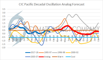
Fig. 2: The Climate Impact Company PDO analog forecast for 2018.

Fig. 3: The Climate Impact Company AMO analog forecast for 2018.
The climate forecast for North America for meteorological spring is mostly based on the ENSO/PDO analog years which are 2012, 2009, 2006, 2001, 1997 and 1996. The AMO analog years are 2017, 2014, 2013, 2007, 2006, 2004 and 1999. Â The ENSO/PDO analog years are weighted twice for spring while summer and autumn equally values the ENSO/PDO and AMO analog years.
U.S. soil moisture is currently quite dry (Fig. 4) most adversely dry in California and the Missouri Valley. Springtime rains could reshape this February profile. The projected early warm season soil moisture profile (Fig. 5) will be applied to the summer outlook whereas large dry soil regions enhance heat risk. The profile is produced by the NCEP CAS (model) and indicates a dry West and Central climate with the (current) eastern dryness eroding.
During non-El Nino regimes the MJO is generally active. The MJO is born in the tropical Indian Ocean and shifts east navigating the global tropics on average in about 7 weeks. As the MJO shifts east the tropical/subtropical climate is affected directly while mid-latitude storm tracks are also affected. The MJO elevates risk of extreme climate events and will continue to be active well into 2018.
Fig. 4: Current soil moisture anomalies across the U.S.

Fig. 5: The end of May 2018 U.S. soil moisture anomaly forecast by CAS.
Climate outlooks: The Climate Impact Company climate outlooks for North America for spring, summer and autumn 2018 follow. The outlooks are based on the analogs previously described, persistence and compared with probabilistic forecasts issued by the International Research Institute for Climate and Society.
MAR/APR/MAY 2018: The meteorological spring 2018 outlook for North America indicates colder-than-normal climate across the far northern U.S. and southwest/south-central Canada. The cold will enable snow cover to persist longer than climatology. Wet conditions forecast in the Upper Midwest U.S. will feature snowy periods into April. Most of the U.S. observes a warmer than normal spring. Warmest anomalies are across the southwestern portion of the U.S. The warmth is accompanied by dry climate as Southwest to parts of the Central U.S. drought strengthens. The East is warmer than normal and includes very dry conditions in the Mid-Atlantic.
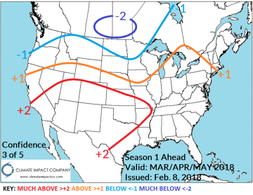

Fig. 6-7: The Climate Impact Company MAR/APR/MAY 2018 temperature and precipitation anomaly forecast for North America.
JUN/JUL/AUG 2018: The meteorological summer 2018 outlook indicates another season of opposing extremes. In the East a persistent upper trough anchors over the Midwest U.S. causing a cooler than normal summer. Along the south and east periphery of the East-Central U.S. trough a wetter than normal season is forecast across previously dry-to-drought areas of the northwest Gulf States and the Northeast Corridor. Meanwhile the western half of the U.S. observes a hotter than normal summer season. Dry-to-drought conditions continue in California and most of the Southwest U.S. and generate in the central/east-central Great Plains region.

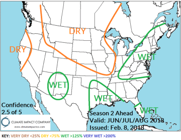
Fig. 8-9: The Climate Impact Company JUN/JUL/AUG 2018 temperature and precipitation anomaly forecast for North America.
SEP/OCT/NOV 2018: Meteorological autumn carries the summer pattern forward as an upper trough maintains a cooler than normal climate Tennessee Valley and into the Southeast U.S. while the West and North U.S. are warmer than normal. Warmest anomalies are across the Great Basin and New England. A dry climate persists in the Midwest U.S. to Great Plains as drought risk for the U.S. Growing Areas heightens. Dryness extends to the Gulf States implying lack of a tropical cyclone risk.
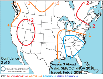
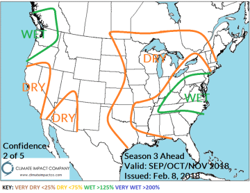
Fig. 10-11: The Climate Impact Company SEP/OCT/NOV 2018 temperature and precipitation anomaly forecast for North America.


