ENSO discussion: Borderline weak La Nina continues in the eastern equatorial Pacific Ocean. The Nino34 SSTA remains within La Nina qualification and the multivariate ENSO index (MEI) indicates a La Nina climate is still present (Fig. 1). Subsurface temperatures in the eastern equatorial Pacific are marginal cool but the trend is warmer (Fig. 2). A Kelvin Wave has moved east of the Dateline adding significantly to upper ocean warmth. Normally, the subsurface observations and trend foreshadow and ENSO phase change. Currently, the warming of the subsurface east of the Dateline implies La Nina will end soon.
The Bureau of Meteorology/Australia announced today that in their view La Nina has ended. The NOAA/CPC Nino34 observations and MEI for JAN/FEB suggest La Nina may last a short time longer.
Presence of the Kelvin Wave moving east of the Dateline is normally a sure-fire signature of an ENSO phase change ahead. Commonly, 3 robust Kelvin Waves shifting east across the Pacific and reaching the northwest coast of South America usually occurring over a period of 4-5 months can dissipate a La Nina and cause an El Nino to develop.

Fig. 1: ENSO phase as defined by Nino34 SSTA and MEI indicates La Nina lingers.
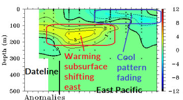
Fig. 2: Subsurface temperatures across the equatorial central and east Pacific indicates a (warm) Kelvin Wave shifting slowly eastward to end La Nina.
The current Kelvin Wave east of the Dateline is the second episode following a weaker event earlier this year. To fully exercise the potential influence of a Kelvin Wave on ENSO and the general climate an east-shifting Madden Julian oscillation (MJO) across the Pacific is necessary. Interestingly, the current MJO (and 30-day forecast) is quiet with no Pacific resurgence expected (Fig. 3).

Fig. 3: ECMWF 30-day MJO forecast indicates a quiet MJO pattern.
Given the possible lack of MJO presence while a Kelvin Wave slips eastward across the equatorial eastern Pacific the warming influence on the entire East Pacific tropics may be suppressed. Despite this potential solution La Nina ends in early spring.
The influence of the Kelvin Wave on the forecast is significant. If forecast models were convinced MJO would align with the Kelvin Wave a longer term forecast favoring weak El Nino would likely be indicated. However, if the short-term Kelvin Wave influence on the East Pacific ENSO regime is muted a neutral ENSO forecast is more likely.

Fig. 4: Bureau of Meteorology/Australia 2018 ENSO phase forecast.

Fig. 5: Climate Impact Company ENSO phase 2018-19 forecast.
Therefore the more likely ENSO phase forecast for 2018 is weakening La Nina followed by neutral ENSO. The Bureau of Meteorology/Australia dynamic Nino34 SSTA forecast indicates neutral ENSO for 2018 (Fig. 4). The Climate Impact Company constructed analog ENSO forecast also indicates neutral ENSO lasting into 2019 (Fig. 5).
The neutral ENSO forecast is not a guarantee. ECWMF indicates El Nino is possible later this year (Fig. 6). Meanwhile NCEP CFS V2 maintains weak La Nina (Fig. 7). The most likely ENSO scenario used to predict climate patterns for mid-2018 is decelerating La Nina. For now, neutral ENSO influence is used as a climate predictor for the second half of 2018.


Fig. 6-7: ECMWF Nino34 SSTA forecast indicates a potential El Nino later this year. Meanwhile the NCEP CFS V2 indicates steady La Nina.
PDO/AMO Discussion: Neutral ENSO influence on climate varies widely and is mostly connected to the SSTA regimes of the ocean areas poleward the tropics. Primary indicators are the Pacific decadal oscillation (PDO) and Atlantic multi-decadal oscillation (AMO).
The Pacific decadal oscillation was in a robust warm phase, one of the strongest on record from 2014 into early 2017. Since that time a flip toward weak cool phase occurred late in 2017 followed by reversal to weak positive phase in early 2018. Normally, PDO phase parallels ENSO but given the weak character of La Nina 2017-18 the cool PDO was temporary. Not surprisingly, the change of PDO back to weak warm phase the last 2 months may have foreshadowed La Nina’s demise.

Fig. 8: The Climate Impact Company PDO constructed analog forecast.
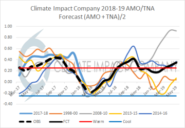
Fig. 9: The Climate Impact Company AMO + TNA constructed analog forecast.
The Climate Impact Company constructed analog forecast of PDO index in 2018 (Fig. 8) indicates a signature similar to last year with warm phase for spring reversing toward weak negative phase next autumn. Forecast confidence is below average. Indicated is +PDO for spring which parallels the expected ending of La Nina followed by mostly neutral phase also correlating to the neutral ENSO forecast.
The Atlantic multi-decadal oscillation cooled significantly in early 2018 especially February. The rapid cooling follows one of the warmest AMO years on record in 2017. The warm AMO and tropical component of the AMO known as the tropical North Atlantic (TNA) index helped fuel the active North Atlantic hurricane season in 2017.
The cooler AMO and cool TNA index in February was a bit of a surprise as forecast models kept the entire North Atlantic basin somewhat warmer-than-normal through the entire winter season. There are some recent signs of a warmer pattern returning.
The AMO/TNA regime is important especially for the summer/early autumn period. Warm phase of AMO/TNA implies stronger than normal subtropical ridging across the North Atlantic and potentially into the eastern U.S. Increased subtropical ridging supports anomalous dry and hot climate. In the tropics, the warm phase of AMO/TNA implies ample upper ocean heat to drive hurricane development.
The Climate Impact Company constructed analog forecast combining AMO and TNA (Fig. 9) indicates slow warming to the warm phase by mid-summer lasting into autumn. Support for above normal number and intensity of hurricanes is implied. Additionally, increase in risk of hot and dry climate in the eastern U.S. (absent a hurricane strike) is also supported.
Conclusions: Lead modes of climate variability supporting climate forecast methodology are ENSO, PDO and AMO. The best estimate of ENSO phase for most of 2018 is a transition from La Nina to neutral phase. Neutral ENSO gives increasing importance to non-tropical SSTA regimes such as PDO and AMO.
The PDO has a tendency to run parallel to ENSO therefore no surprise that most of the PDO forecast in 2018 involves neutral phase. AMO is neutral now expected to rewarm to the positive phase for summer into autumn 2018.
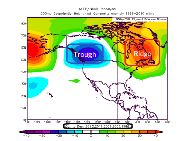
Given the relatively weak SSTA-based regimes projected for 2018 the best climate forecast methodology is based on decelerating La Nina for quarter 2 of 2018 and neutral ENSO for the second half of 2018. Based on this approach the 500 MB anomaly pattern for quarter 2, 3 and 4 across the U.S. are indicated.
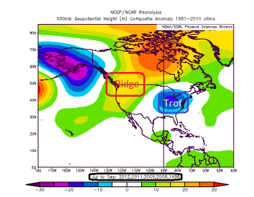
Reasonably confident is a quarter 2 of 2018 upper air pattern featuring a high pressure ridge causing heat and dryness over Texas and vicinity while a cool/wet trough anchors near the Northwest (Fig. 10). During quarter 3 of 2018 the upper trough shifts to the East U.S. while a pattern-changing upper ridge emerges in the West (Fig. 11). Quarter 4 of 2018 finds an amplified trough in western Canada while a ridge pattern occupies eastern Canada (Fig. 12). Other factors will produce adjustments to these forecasts however the base prediction indicated is reasonably confident.
Sensible weather implications of these 500 MB anomaly forecasts for quarter 2 of 2018 indicate…
- Hot and dry in Texas and the southern Great Plains.
- Drought Southwest U.S. to western Texas to the central Plains.
- Cool/showery regime far Northwest U.S.

Sensible weather implications of these 500 MB anomaly forecasts for quarter 3 of 2018 indicate…
- Suppressed heat in the East.
- Dryness and heat expand from the Southwest across most of the West.
- Chance of expanding dryness Central on back side of trough.
- Tropical cyclones move west into the Gulf toward Texas/Mexico, turn away from the East Coast.
Sensible weather implications of these 500 MB anomaly forecasts for quarter 4 of 2018 indicate…
- Susceptibility to cold Northwest and warmth East/Northeast.
- Some dry/drought relief Central U.S.